
Study on water loss settlement law of loose aquifer based on distributed optical fiber
-
摘要:
煤矿开采扰动间接引起的地下水散失会使松散层压缩,造成地表沉降,威胁煤矿安全生产。为深入分析此类非采动因素对松散含水层失水沉降的影响,根据已有的地质水文资料将研究区松散层自上而下划分为一含、一隔、二含、二隔、三含、三隔和四含。利用分布式光纤监测技术、水文观测技术和土力学实验对研究区域松散含水层进行全面观测,分析了非采动情形下各层位的形变特征,探究了深层隔水层的黏土弱化规律,明确了深层含水层形变量和该层位水头高度变化之间的关系。结果表明:①四含及上部部分隔水层持续压缩是造成研究区域地表沉降的主要原因。对地层形变贡献最大的两个层位分别为四含和一含,其中一含形变具有季节性特征,春季夏季抬升,秋季冬季沉降,而四含则在观测周期内呈持续沉降态势。②结合布设水文孔、分布式光纤和土力学实验,实现了对目标层位黏土弱化程度的监测,研究区四含上覆黏土层受四含地下水的影响产生黏土弱化,其弱化程度与埋深成反比,与地下水流通性成正比,黏土层弱化将导致含水层顶部隔水层压缩,加剧地表沉降。③四含形变与四含层位水头高度变化的趋势一致,两者呈线性关系,观测结果与理论计算结果相符,表明四含失水是造成四含压缩形变的主要原因。
Abstract:Indirect water loss caused by disturbance from coal mining can cause compression of loose layers and surface subsidence, which poses a threat to coal mine safety. To analyze the effects of such non-mining factors on water loss and subsidence of loose aquifers, the study area was divided into seven layers from top to bottom based on existing geological and hydrological data. Using distributed fiber optic monitoring technology, hydrological observation techniques, and soil mechanics experiments, the loose aquifer in the study area was comprehensively observed and the deformation characteristics of each layer under non-mining conditions were analyzed. The weakening law of the deep aquitard was explored, and the relationship between the deformation of the deep aquifer and the water head height of that layer was determined. The results show that: ① continuous compression of the fourth aquifer and its upper part of the aquitard is the main cause of surface subsidence in the study area. The two layers that contribute the most to the deformation of the strata are the fourth and first aquifers, with the latter showing seasonal deformation characteristics. The fourth aquifer exhibits a continuous subsidence trend during the observation period. ② By combining hydrological boreholes, distributed fiber optic and soil mechanics experiments, monitoring of the degree of clay weakening of the target layer was achieved. The clay layer above the fourth aquifer in the study area is weakened by the impact of the groundwater in the fourth aquifer. The degree of weakening is inversely proportional to the burial depth and directly proportional to the permeability of the groundwater, and the weakening of the clay layer will cause compression of the aquitard at the top of the aquifer and exacerbate surface subsidence. ③ The deformation of the fourth aquifer is consistent with the trend of changes in the water head of the fourth aquifer, and the two are linearly related. The observation results are in agreement with the theoretical calculation results, indicating that water loss from the fourth aquifer is the main cause of its compression deformation.
-
0. 引 言
我国每年新掘进巷道总长度约12 000 km[1],其中软岩巷道的开掘比例占到10%以上,且广泛分布在我国20多个矿区[2-3]。软岩巷道围岩松散破碎,稳定性差,流变性强,变形量大且持续时间长,巷道通常需要多次翻修才能满足生产要求,这严重制约煤矿的安全高效生产和经济效益增长[4-5]。
长期以来,相关学者围绕软岩巷道稳定围岩控制做了大量的研究工作,并取得了丰富的研究成果。主要集中在以下3个方面:①提高支护强度。康红普等[6]提出的高预应力强力支护理论强调了预应力和锚杆刚度在软岩巷道支护中的重要性,通过强化锚杆支护系统各配件间的相互作用来提高整体强度,高预应力、强力锚杆与锚索联合支护技术可以控制软岩巷道围岩变形。余伟健等[7]针对软岩巷道的返修提出了差异性支护的控制方法,针对不同变形采用不同支护强度来进行控制。张红军等[8]针对软岩的大变形问题提升了支护强度,开发了高预应力增阻大变形锚杆。付玉凯等[9]提出的长短锚索层次控制技术有效的控制了软岩巷道围岩变形。吴拥政[10-11]针对研究了锚杆附件之间的力学匹配性并开发了全长预应力支护系统,相比一般锚杆支护,使得对软岩巷道的锚杆支护更具有针对性且强度有了明显提高。②强化围岩承载能力。何满潮等[12]针对高应力强膨胀节理化软岩巷道提出了刚柔层桁架耦合支护技术,依此强化围岩承载能力,保持巷道围岩稳定。张广超等[13]研究了应力扩容膨胀型(HJS)复合地质软岩巷道稳定,提出以高强锚网索、可缩性环形支架、注浆加固为核心的多层次耦合支护系统。孙晓明等[14]针对软岩巷道提出以恒阻大变形锚杆为核心的耦合支护技术能够有效转化变形力学机制,安全吸收岩体中积聚的变形能,有效地阻断底鼓塑性滑移作用力。黄庆享等[15]针对软岩大变形巷道围岩控制难题,优化了巷道断面形态,重点强调了全断面锚杆索支护并注浆,增强了围岩承载能力。柏建彪等[16]针对软岩巷道支护原理进行了系统研究,强调了提高软岩自身承载能力的重要性。刘高等[17]分析了软岩巷道围岩的变形破坏机理,明确了围岩承载能力弱是软岩巷道变形破坏的重要原因。靖洪文等[18]分析了注浆对提高软岩巷道围岩承载能力的作用机理。王卫军等[19]研究了软岩巷道围岩塑性区扩展,认为强化围岩承载能力可以控制围岩塑性变形破坏。③软岩遇水的控制。由于软岩遇水表现出明显的变形蠕变、流变特性,使得控制难度明显增加,许兴亮等[20]研究了泥岩遇水情况下的巷道围岩变形规律,提出该类型巷道围岩的动态过程控制技术。高明仕等[21]针对软岩巷道强流变四周均表现出大变形的破坏特征,提出了全断面,全支全让“O”型封闭控制的支护原理,强调了强力与卸压并存的支护方法。刘泉声等[22]针对软岩的破碎碎涨变形研究了锚喷与注浆协同的控制过程,提出了相应的控制思路。
上述研究成果对软岩巷道围岩稳定性控制发挥了积极的作用。然而,鉴于煤矿地质条件的复杂性,许多软岩矿区的巷道围岩控制难题尚未得到完全解决。笔者选择宁煤清水营煤矿110207运输巷含水软岩巷道为研究对象,结合现场实测,分析了巷道变形破坏的主要特征,研究了巷道围岩“一水三弱”的特征及变形破坏机理,提出了“一隔三强”的巷道围岩控制的原理,在此基础上,提出了全断面“锚索+网+注浆+喷浆”的综合支护技术,现场实践表明,巷道围岩控制效果良好。研究成果可为软岩巷道围岩控制提供一定的理论与技术参考。
1. 工程概况及变形特征
1.1 工程概况
清水营煤矿110207工作面运输巷沿2煤顶板掘进,2煤平均厚度4.77 m,内生裂隙发育,夹矸岩性为粉砂质泥岩,属简单结构煤层。2煤伪顶为平均厚度0.31 m的泥岩,灰黑色,破碎、团块状;直接顶为粗粒砂岩,平均厚度32.74 m,夹杂薄层泥岩及煤线;基本顶为平均厚度5.53 m的粉砂岩和19.61 m的粗粒砂岩,泥质胶结。2煤直接底为泥质粉砂岩,平均厚度1.22 m,泥质胶结,局部夹薄层细砂岩;基本底为平均厚度5.46 m的细粒砂岩与4.53 m的中粒砂岩,泥质胶结,较坚硬,属次软岩石。110207运输巷岩性柱状如图1所示。
对110207运输巷内顶板及帮部围岩进行了钻孔窥视,发现顶板上方4.0~5.5 m赋存有弱含水层,施工钻孔时可见线状淋水,根据Q602-2钻孔抽水试验资料,直罗组砂岩含水层(Ⅲ)单位涌水量q=0.009 9 L/(s·m),渗透系数k=0.009 6 m/d,富水性弱。顶板与帮部裂隙较发育,部分顶板与帮部结构窥视如图2所示。
![]() 图 2 110207运输巷顶板与帮部结构窥视Figure 2. Borehole peering images of roof and side of transportation roadway No. 110207
图 2 110207运输巷顶板与帮部结构窥视Figure 2. Borehole peering images of roof and side of transportation roadway No. 110207借助X射线衍射仪对110207运输巷顶底板围岩矿物成分进行了分析,顶底板黏土矿物平均含量大于30%,在黏土矿物中平均蒙皂石类占比15%、伊利石占比11%、高岭石占比60%、绿泥石占比10%,此类围岩遇水后极易软化、泥化,严重影响巷道的稳定性。
对110207运输巷顶板与帮部围岩进行了单轴抗压强度原位测试,测试结果如图3所示,从测试结果可知,顶板8 m以内0~5.0 m岩石强度低于15 MPa,5.0~7.2 m岩石强度处于15~25 MPa,7.2~8.0 m岩石强度处于15 MPa以下,帮部为平均强度11 MPa的煤体。依据现场实测并参照GB 50218—1994《工程岩体分级标准》中对岩石强度分类的描述,顶板与帮部围岩均属于软岩范畴。
![]() 图 3 110207运输巷顶板与帮部强度实测曲线Figure 3. Measured strength curves of roof and side of transportation roadway No. 110207
图 3 110207运输巷顶板与帮部强度实测曲线Figure 3. Measured strength curves of roof and side of transportation roadway No. 110207110207运输巷断面为圆弧拱形,净宽×净高=5.5 m×3.75 m,净断面为17.0 m2。原支护参数如下:
锚索:拱部与帮部锚索规格分别为ø21.98 mm×5300/3300 mm,间排距分别为2000/1500 mm×2000 mm。单根5.3 m锚索采用1节MSK2370与2节MSZ2370的树脂锚固剂,单根5.3 m对比3.3 m锚索减少1节MSZ2370的树脂锚固剂;预紧力不小于150 kN,采用300 mm×300 mm×16 mm的蝶形托盘。
锚杆:采用ø22 mm×2 500 mm的左旋无纵筋螺纹钢锚杆,间排距1000 mm×1000 mm,单根锚杆配1节MSK2370和1节MSZ2370的树脂锚固剂,预紧扭矩不小于240 N·m,采用150 mm×150 mm×10 mm的蝶形托盘。
锚网:顶板为ø6.5 mm圆钢加工的网孔为100 mm×100 mm的钢筋网;帮部为网孔40 mm×40 mm的钢塑网。
喷层:喷射混凝土强度等级为C20,铺底混凝土强度等级为C25,支护断面及参数如图4所示。
![]() 图 4 110207机巷断面及原支护设计参数Figure 4. Original support scheme of transportation roadway 110207
图 4 110207机巷断面及原支护设计参数Figure 4. Original support scheme of transportation roadway 1102071.2 巷道变形破坏特征
110207运输巷自掘进以来,由于顶板淋水、围岩岩性差等多种原因,巷道变形破坏严重,变形破坏照片如图5a所示,巷道围岩变形曲线如图5b所示。
![]() 图 5 110207运输巷变形破坏现场与曲线Figure 5. Deformation failure images and curves of headentry No. 110207
图 5 110207运输巷变形破坏现场与曲线Figure 5. Deformation failure images and curves of headentry No. 110207从图5b可知,110207运输巷变形破坏呈现以下特征:
巷道围岩变形量大,底鼓严重。110207运输巷在掘进期间矿压显现强烈,顶板下沉、两帮内挤和底板严重鼓起。在近60 d的监测中,顶底板移近量大于1 400 mm,两帮移近量大于400 mm,且围岩变形持续增加。已掘进的2 300多米巷道有30%以上属于变形破坏严重地段。
围岩变形持续时间长。110207运输巷围岩在掘进期间一直处于变形之中。从变形曲线可以看出,整个变形破坏过程分为初期初始变形、中期急速变形与后期缓慢变形3个阶段。
围岩变形速度快。巷道顶底板7 d内的初期初始变形200 mm以上,占总变形量的10%。中期14 d急速变形600 mm以上,约占总变形量的30%。即使后期40 d,每天的移近量也大于15 mm。如此快的变形速度导致巷道控制更加困难。
综上所述,清水营煤矿110207运输巷属于典型的弱含水层下软岩大变形巷道。
2. 软岩巷道围岩变形破坏机制
2.1 变形破坏原因
根据现场调研与实测,结合巷道围岩变形破坏特征,影响弱含水层下软岩巷道围岩变形破坏主要有以下4个方面:
巷道围岩强度低、承载能力弱。110207运输巷顶板岩石强度平均15 MPa,帮部煤体强度平均11 MPa,顶板围岩在5.5 m范围内结构发育。此类型围岩自身强度与整体性都比较差,不具备较强的承载能力。
围岩含高比例黏土矿物成分且顶板存在淋水,X射线衍射试验表明围岩黏土类矿物成分占比大于30%,且含有高岭石、蒙脱石等膨胀性岩石,这些高比例黏土矿物遇到顶板淋水极易发生膨胀与崩解。
锚杆(索)锚固根基薄弱,锚杆(索)难以与围岩锚固稳定。巷道围岩裂隙发育,钻孔壁完整性差,锚固剂与围岩之间容易松动,加之水与泥岩的作用,大幅降低了锚固剂与钻孔壁之间的粘结力,现场测试裂隙淋水区域30%以上的锚杆(索)拉拔力小于80 kN。
原支护方案设计不合理,不能适应软岩巷道围岩大变形。原支护方案设计不能与围岩充分耦合,护表面积小且强度低,支护系统对巷道围岩的整体控制作用有限。现场实测,锚杆(索)施加的预紧力低,部分锚杆与锚索预紧力仅为20 kN和70 kN,难以实现锚杆(索)的主动支护作用,尤其是忽略了底板的支护,极易引起底鼓。
2.2 变形破坏数值模拟
为明确110207运输巷在原方案下的变形破坏特征,揭示软岩巷道围岩的变形破坏机制,以110207运输巷原支护方案及地质资料为基础,建立计算模型。模型尺寸:75 m×75 m×10 m;模型上边界为自由边界,下边界固定;上边界施加均布垂直应力12.5 MPa,数值计算模型如图6所示。依据现场实测的地质力学参数,最大水平主应力σH=13.52 MPa,垂直主应力σv=11.3 MPa,侧压系数λ取1.2,并参考GB 50218—1994《工程岩体分级标准》,数值模拟物理力学参数见表1。
表 1 数值模拟的围岩物理力学参数Table 1. Rock mechanics parameters of numerical simulation岩性 内摩擦角φ/(°) 黏聚力C/
MPa抗压强度/
MPa弹性模量E/
MPa粉砂岩 28 3.5 24 8.5 粗粒砂岩 32 3.8 20 10.6 泥岩 18 0.6 12 3.7 2煤 20 1.1 11 4.8 泥质粉砂岩 21 0.8 16 2.6 细粒砂岩 23 3.0 22 5.2 中粒砂岩 34 1.8 20 4.6 如图6b所示,原支护方案锚杆预紧力为20 kN,在此情形下,两帮锚杆在水平方向上形成的压应力区可以相互交织彼此相连,但其最大值仅为0.17 MPa,锚杆在拱顶形成的压应力区有限且不相连。如图6c所示,锚杆在拱顶形成的垂直方向支护应力场有限,基本上呈单独状态,对围岩的挤压控制作用小,锚索的预紧力为70 kN,可在锚索范围内形成宽度约1.0 m的压应力区,应力区平均值约0.12 MPa。由此可见,原支护方案下锚杆(索)的支护应力场无论范围还是大小对控制软岩大变形都明显不足,后期围岩必然出现变形破坏。
对模型进行迭代显式求解,巷道围岩变形破坏形态如图7所示。
从图7a与图7b可以看出,原支护方案下110207运输巷变形破坏严重,整个巷道断面收缩50%以上。底板深部4.0 m范围内岩层均出现不同程度的变形破坏,两帮围岩破坏深度达3.8 m。从位移云图可知巷道底板变形最为强烈,底鼓量达到2.7 m,顶板中部最大下沉量0.63 m,左帮内挤0.83 m,右帮内挤0.73 m。
从图7c可以看出,110207运输巷围岩塑性区范围大且形态不规则,反映在围岩各个区域就是不同程度的变形破坏,底板塑性区分布最大边界达8.3 m、左帮3.5 m、右帮2.5 m、顶板3.0 m。底板与帮部的变形既有剪切破坏又有张拉破坏,顶板以剪切破坏为主。
2.3 变形破坏机制
为更直观地分析软岩巷道围岩变形破坏过程,将巷道围岩浅表变形破坏数据整理为变形曲线,如图8所示。
![]() 图 8 数值模拟巷道围岩变形曲线Figure 8. Numerical simulation deformation curve of roadway surrounding rock
图 8 数值模拟巷道围岩变形曲线Figure 8. Numerical simulation deformation curve of roadway surrounding rock从图8可以看出,巷道围岩变形呈现出与实测曲线图5b一致的变形破坏特征,变形破坏分为初始增加、急速增加与缓慢增加3个阶段。为分析巷道围岩变形破坏机理,提出如图9所示的模型。
![]() 图 9 巷道围岩变形破坏机理示意Figure 9. Schematic of deformation and failure mechanism of roadway surrounding rock
图 9 巷道围岩变形破坏机理示意Figure 9. Schematic of deformation and failure mechanism of roadway surrounding rock分析图9可知,弱含水层下软岩巷道a开挖后,巷道围岩应力σ平衡被打破而进行二次平衡,在此过程中若锚杆预紧力P偏低不能及时主动控制浅表围岩的变形,浅表低强度围岩就不可避免出现变形破坏。
随着巷道围岩的变形,围岩裂隙逐步增多,节理、裂隙及锚杆(索)孔等逐步交织,与弱含水层贯通形成复杂的含水结构网。水与围岩中的高比例黏土矿物相互作用,不仅发生膨胀崩解变形,而且弱化了锚固剂与围岩壁之间的抗剪强度τ,随着应力平衡往围岩深部推进,巷道围岩变形量开始急速增加。由于巷道浅部围岩的急速变形,围岩应力得到一定释放,围岩变形量得以暂时性缓慢增加,应力向深部转移,此时进入缓慢增加阶段。在此阶段内,围岩裂隙的发育、水黏土矿物反应或者其它因素导致锚固剂、锚杆(索)、钻孔壁三者之间脱锚,导致锚杆(索)支护失效,进而导致巷道围岩大变形或冒落等严重矿压显现。
3. 弱含水层下软岩巷道“一隔三强”协同控制
3.1 控制方法
根据上述分析可知,弱含水层下巷道围岩变形破坏的主要影响因素为围岩黏土矿物成分高且遇水、锚杆(索)锚固基础弱、锚杆(索)预紧力扩散效果差、围岩承载能力弱4个方面,即“一水三弱”。所以,该类巷道围岩控制可从这4个方面开展研究。
1)隔:隔是指隔断水与围岩黏土矿物成分的接触,防止围岩出现膨胀、崩解而大变形。可以从含水源、水的流通途径、水的作用地3方面开展工作。如采用注浆的方法充填裂隙网络阻断水的流通,采用喷浆涂层的方法在黏土围岩表面形成隔离层阻断与水接触,采用全长锚固方式封闭钻孔等方法。
2)强基:强基是指强化锚杆(索)的端部一次性锚固基础,防止锚固基础松动和滑动,为发挥锚杆(索)的主动支护作用提供牢固基础。可以从保持钻孔壁完整性、改变锚杆(索)锚固段形态以增加阻力、改变锚固剂性能(膨胀性、防水性等)增加锚固力、增加锚固段长度等方法开展强化锚固基础的工作。如注浆封闭裂隙保持钻孔壁完整并阻断水流入,增加锚固段长度或编制鸟笼增加锚固段阻力,在淋水钻孔内应用防水锚固剂强化锚固效果等,都能取得不错的锚固效果。
3)强表:强表是指强化围岩表层的强度、完整性与平整性,为提升锚杆(索)预应力的扩散提供可靠的表层。可以从提高围岩浅表强度、平整围岩表层凹凸面、增加护表构件面积与强度等方面开展工作。如喷射混凝土或采用垫层来平整围岩表层凹凸面,采用大尺寸W钢护板等方法均可达到强化表层的目的。
4)强承载:强承载是增强锚固范围内围岩自身的承载能力。可以从围岩自身改性、提高锚杆(索)杆体强度、提高锚杆(索)预紧力等方面开展工作。如利用注浆材料注入岩体内使围岩的性能得到强化,提高锚杆(索)的杆体直径或强度,使用大扭矩设备、张拉设备、减摩垫圈等来提高锚杆(索)预紧力,这些方法都可以有效增强锚固范围内围岩的承载能力。
3.2 控制原理
基于上述分析,弱含水层下软岩巷道围岩控制除采用传统支护方式外,提出“一隔三强”的控制方式主要体现在以下3个方面:①对于新掘巷道,在开挖前向掘进面水源进行深孔注浆,以排挤水源远离巷道,开挖后立即喷射混凝土层封闭裸露岩层并保持新开挖岩面平整。对于返修巷道可以选择流动性强、快凝材料进行深浅孔搭配注浆,封闭淋水通道的同时提高围岩的完整性;同时将支护构件淋水进行引流,统一管道排走。总之,隔即防止淋水与黏土围岩接触。②注浆后,采用高预紧力全长锚固支护,采用性能优良的特种锚固剂(防水、膨胀或其它)进行一次性端锚牢固,然后施加杆体30%~60%屈服强度的预紧力,最后进行全孔注浆以实现全长锚固,并进行围岩全断面二次高强度材料注浆强化围岩强度。③支护完成后,再次喷浆直至封闭锚杆(索)尾部及支护构件。弱含水层下软岩巷道围岩“一隔三强”协同控制如图10所示。
![]() 图 10 “一隔三强”协同控制原理示意Figure 10. Control principle schematic of “one obstruct and three strengthen” of roadway surrounding rock
图 10 “一隔三强”协同控制原理示意Figure 10. Control principle schematic of “one obstruct and three strengthen” of roadway surrounding rock弱含水层下软岩巷道隔离水与岩体接触:高比例黏土矿物岩层内含有大量的高岭石、蒙脱石、伊利石,这些都属于硅铝酸盐类,其晶体形状为层片状,在有水情形下层间会吸附和填充大量的水,导致体积增加数倍乃至数十倍,此时岩体具有明显的胶体性质,包括膨胀性、流变性、分散性和絮凝性。反映在110207运输巷中表现就是泥岩膨胀破碎、分散崩解,或变为絮凝状具有一定的流动性,强度大幅降低。为防止水与软岩的相遇,可以采用围岩内注浆与浅表喷浆涂层相结合的方式驱赶水源、封闭水流路径,降低水与高黏土矿物接触的机会,保证围岩强度稳定。
弱含水层下软岩巷道强基强表强承载控制:在注浆后的岩层内,利用特种锚固剂配合增阻锚固段锚杆(索)等来强化锚固基础,利用大面积高刚度护表构件、岩面表面喷层来强化支护阻力传导层,利用高强度杆体、二次注浆、全长锚固、高预紧力等强化锚固承载层。利用“三强”锚注支护可以有效阻止围岩的大变形。
采用“一隔三强”的目的就是为控制围岩大变形,研究表明[22],弱含水层下软岩巷道围岩变形可以用下式表示:
$$ \sum \mu = {\mu _{\text{e}}} + {\mu _{\text{p}}} + {\mu _{\text{w}}} + {\mu _{\text{q}}} + {\mu _{\text{b}}} $$ (1) 其中:
$ {\mu }_{\text{e}}、{\mu }_{\text{p}}、{\mu }_{\text{w}}、{\mu }_{\text{q}}、{\mu }_{\text{b}} $ 分别为围岩的弹性、塑性、遇水膨胀、重力与碎胀扩容变形。弹性变形$ {\mu _{\text{e}}} $ 为巷道围岩弹性变形量,$ {\mu _{\text{w}}} $ 通过隔断水与泥岩相遇可避免或减少,$ {\mu _{\text{q}}} $ 表示巷道开挖后巷道围岩的重力变形不足以影响围岩稳定。已有研究成果[23]表明,
$ {\mu }_{\text{p}}和{\mu }_{\text{b}} $ 是在塑性区扩展过程中出现的变形,塑性区半径R0越大破碎区越大,破碎扩容变形$ {\mu _{\text{b}}} $ 就越大,这2种变形与塑性区半径R0关系密切,R0可用下式表示:$$ {R_0} = a{[({p_{\rm{z}}} + c \cot \;\phi )(1 - \sin\; \phi )/{p_{\rm{i}}} + c \cot\; \phi ]^{\frac{{1 - \sin \;\phi}}{{2\sin\; \phi }}}} $$ (2) 由式(2)可知巷道围岩塑性区半径
$ {R_0} $ 是与岩石力学参数$ c $ 和$\phi $ 、巷道围岩半径a、地应力$ {P_{\text{z}}} $ 成正比例关系,与支护阻力$ {P_{\rm{i}}} $ 及支护强度成反比例关系。注浆后可以提高裂隙围岩的黏聚力和内摩擦角,施加足够的预紧力可以提高支护阻力
$ {P_{\rm{i}}} $ ,因此注浆和支护可以有效抑制塑性区半径R0的扩展,从而降低$ {\mu }_{\text{p}}和{\mu }_{\text{b}} $ ,使巷道围岩的大变形得到控制。弱含水层下软岩巷道“一隔三强”的时空关系:总体原则为隔离水源与软岩接触应早于“三强”支护。即在巷道开挖前可以对水源采取一定的措施排挤,开挖后采用注浆方式对围岩封闭围岩裂隙或密封或排放可能的漏水点,然后依次进行强基、强表与强承载“三强”支护,最终实现弱含水层下软岩巷道“一隔三强”的协同控制。
3.3 控制方案
依据上述“一隔三强”控制原理,结合110207运输巷地质条件,提出全断面“深孔注浆+锚网索喷注”的联合控制方案。
首先借助深孔预注浆对全断面淋水通道进行封闭,隔断淋水与围岩、锚固岩层的接触通道,同时提高围岩的整体性;然后借助特种高强锚固剂与增阻锚索段强固锚固基础,选用喷浆、提高护表构件面积与强度来强化支护阻力传导表层;再次给锚索施加足够的预紧力,后借助中孔注浆锚索二次注浆来增加锚固圈层的承载能力。全断面“深孔注浆+锚网索喷注”的联合控制方案如图11所示。
![]() 图 11 巷道支护加固控制方案Figure 11. Control scheme of support and reinforcement in test section
图 11 巷道支护加固控制方案Figure 11. Control scheme of support and reinforcement in test section借助工程类比、数值模拟及现场经验得出分别对锚杆(索)的排距、间距、长度及直径等参数进行模拟优化,得出的支护参数如下:
1)锚索支护。锚索规格:ø×L=21.8 mm×6 300/4 300 mm的钢绞线,顶板间排距为2 000 mm×2 000 mm,帮部间排距为1 000 mm×1 000 mm,底板间排距为1 000 mm×1 000 mm。锚固方式:先采用特种防水树脂锚固剂实现端锚(每根锚索采用1节K2335与2节Z2360树脂锚固剂),对锚固基础进行初期强化,渗水区域锚固力不低于160 kN,然后借助锚索注浆实现全长锚固,同时保护钻孔壁完整阻断孔内渗水流水而保护锚固基础长期稳固。锚索托盘为300 mm×300 mm×16 mm的拱型托盘,锚索张拉力不低于140 kN。
2)喷网:采用ø6.5 mm的钢筋网,网孔规格100 mm×100 mm。顶与帮喷射混凝土层厚不低于100 mm,底板混凝土层厚不低于500 mm。通过喷网提高巷道围岩的表层强度,强化支护阻力传导层,为锚索的预应力有效扩散奠定坚实的基础,也可阻止表层水进入巷道空间。
3)注浆方案:顶板注浆孔深7.0 m,两帮注浆孔深6.0 m,两帮的间排距均为1 500 m×2 000 m,顶板间排距为2 000 m×2 000 m。注浆一方面可以明显改善围岩的黏聚力与内摩擦角,强化锚固区域围岩的承载性能,另一方面充填裂隙网络阻断水的流通,同时是再次对锚索锚固基础的二次强化。
4. 工程实践与效果分析
将提出的“一隔三强”控制方案应用于现场实践,并在不同区段进行围岩变形量监测与注浆前后结果窥视对比分析,巷道围岩顶板窥视结果如图12所示。
由图12a可知,巷道围岩注浆前围岩裂隙发育,钻孔内可见纵横裂隙,钻孔壁完整性非常差,可见淋水沿孔壁下流,在该类围岩中做锚索拉拔试验,拉拔力小于100 kN;由图12b可知,围岩注浆后围岩裂隙被封闭,钻孔内可见灰白色浆液脉络,钻孔壁完整,未见淋水出现,现场实测拉拔力可大于180 kN。
为了对新支护方案的效果进行检验,在试验段布置了综合矿压监测点,分别对锚索受力、巷道围岩变形量进行监测。锚索受力和巷道围岩变形如图13和图14所示。
![]() 图 14 巷道围岩变形曲线Figure 14. Deformation curve of roadway surrounding rock in test section
图 14 巷道围岩变形曲线Figure 14. Deformation curve of roadway surrounding rock in test section由图13可知,巷道不同部位的锚索受力曲线表现出明显的起伏特性,前期变化较大,后期逐步趋于稳定。在前期的15 d之内锚索受力逐步增加,顶板锚索由149 kN增加到168 kN,左帮由159 kN增加到174 kN,右帮锚索受力处于缓慢增加状态,15 d之后锚索受力逐步趋于稳定,表明巷道围岩变形逐渐稳定。
由图14可知,采用新的联合控制方案后,巷道两帮最大移近量为51.9 mm,顶底板最大移近量为27.8 mm,之后变形趋于稳定,收敛速率均小于1 mm/d,巷道可满足正常使用。因此,通过“一隔三强”的全断面“深孔注浆+锚网索喷注”联合控制支护可以较好地控制弱含水层下软岩巷道围岩大变形。
5. 结 论
1)清水营煤矿110207运输巷表现出明显的“一水三弱”特征,即水与高比例黏土矿物岩层共存、弱锚固基础、弱支护阻力传导表层和弱承载性能,受此影响,原支护方式不能适应围岩大变形,该巷属于典型的弱含水层下软岩大变形巷道。
2)针对巷道 “一水三弱”特征,提出了控制弱含水层下软岩巷道的“一隔三强”控制原理,即隔水、强化锚固基础、强支护阻力传导表层、强化围岩承载能力,并提出了围岩控制方法。
3)依据“一隔三强”的控制原理,提出了全断面“锚索+网+注浆+喷”的综合控制方案,并进行了现场试验。矿压监测结果表明:巷道两帮最大移近量为51.9 mm,顶底板最大移近量为27.8 mm,围岩变形量小,保证了巷道的安全正常使用。
-
![]()
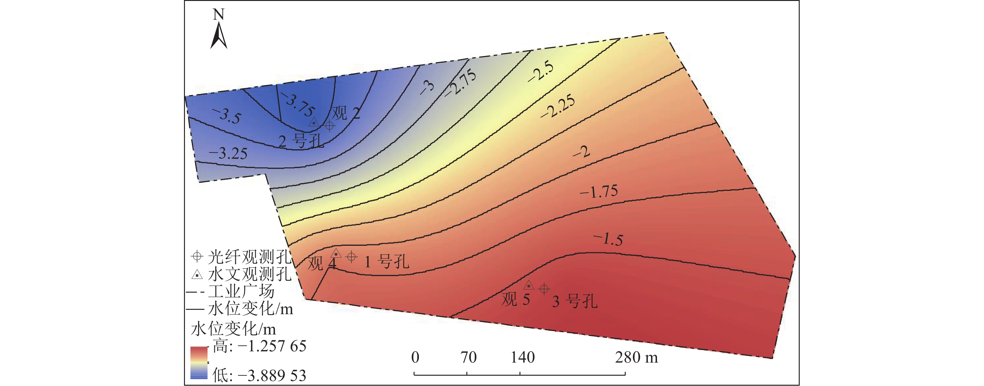
图 1 研究区、光纤观测孔和水文观测孔位置
Figure 1. Location of study area, optical fiber observation hole and hydrological observation hole
![]()
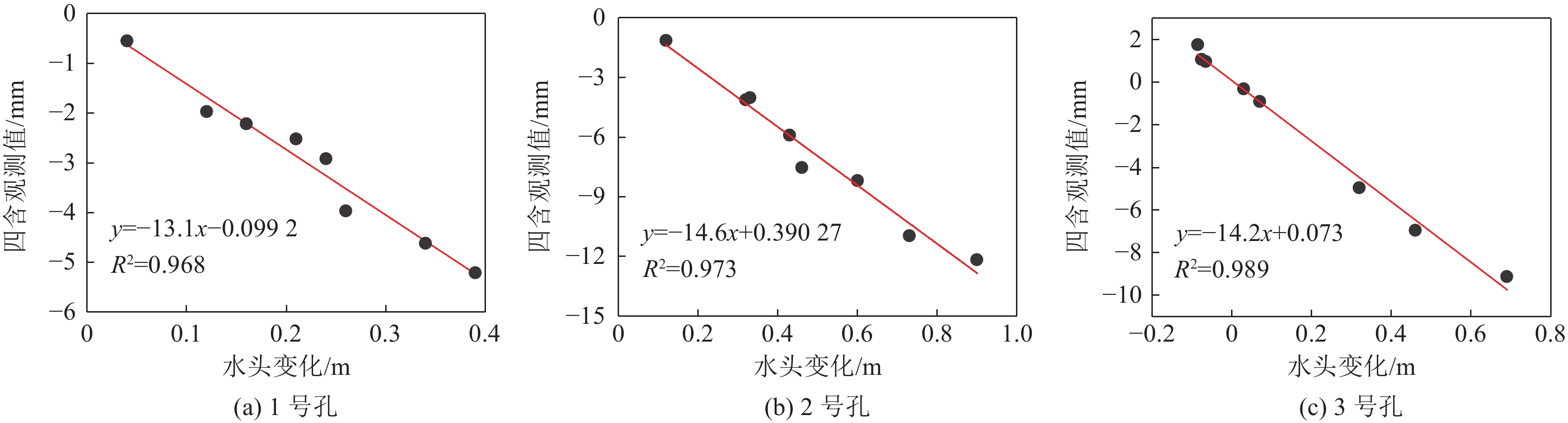
图 7 四含形变与四含水头高度拟合
Figure 7. Fitting of four-water deformation and four-water head height
表 1 研究区域地层划分
Table 1 Stratigraphic division of the study area
层位 厚度/m 累计深度/m 一含 35.45 35.45 一隔 29.01 64.55 二含 18.85 83.40 二隔 28.05 111.45 三含 30.02 141.65 三隔 82.65 224.30 四含 7.08 232.10  下载: 导出CSV
表 2 商用fTB2505型 BOFDA光纤解调仪参数
Table 2 Parameters of commercial fTB2505 BOFDA fiber optic interrogator
参数 取值 参数 取值 最大监测范围/dB >20 最高采样分辨率/m 0.05 光纤类型 单模 应变测试重复性/10−6 $ \leqslant \pm 4 $ 最高空间
分辨率/m0.2 频率扫描范围/GHz 9.9~13.0 应变测试精度/10−6 <2 接口 以太网 应变测试范围/10−6 −30000~
30000光输出接口 E-2000, APC 最大测试量程/km 50 数据输出格式 Binary, ASCII
下载: 导出CSV
表 3 各层位土力学试验结果
Table 3 Experimental results of soil mechanics at each layer
层位 埋深/m 平均
含水率/%平均密度/
$({\rm{kg}}·{\rm{c}}{{\rm{m}}}^{-3})$平均初始
孔隙比平均压
缩系数平均压
缩模量三隔 层a 205~210 16.5 2.32 0.36 0.11 10.84 层b 210~213 18.8 2.04 0.58 0.02 5.15 层c 213~216 9.7 2.17 0.37 0.01 10.28 层d 216~220 11.5 2.39 0.26 0.01 10.38 四含 224.5~232.1 16 2.25 0.39 0.02 5.48
下载: 导出CSV
-
[1] 刘孝孔,绪瑞华,赵艳鹏,等. 邻近厚松散层既有立井井筒地面注浆地层加固技术[J]. 煤炭科学技术,2022,50(7):127−134. doi: 10.13199/j.cnki.cst.2020-1081 LIU Xiaokong,XU Ruihua,ZHAO Yanpeng,et al. Ground grouting stratum reinforcement technology for existing vertical shafts adjacent to thick loose layers[J]. Coal Science and Technology,2022,50(7):127−134. doi: 10.13199/j.cnki.cst.2020-1081
[2] 程 桦,周瑞鹤,姚直书,等. 厚表土薄基岩凿井突水溃砂井筒破坏治理技术研究[J]. 煤炭科学技术,2021,49(4):176−185. CHENG Hua,ZHOU Ruihe,YAO Zhishu,et al. Research on wellbore damage control technology for drilling well with thick topsoil and thin bedrock, water inrush and sand burst[J]. Coal Science and Technology,2021,49(4):176−185.
[3] 陈 芳,张劲满,徐良骥,等. 厚松散含水层失水沉降相似模拟实验研究[J]. 工矿自动化,2022,48(1):78−84. CHEN Fang,ZHANG Jinman,XU Liangji,et al. Simulation experiment research on dehydration settlement of thick unconsolidated aquifer[J]. Journal of Mine Automation,2022,48(1):78−84.
[4] 李文平,于双忠. 徐淮矿区深部土体工程地质特性及失水变形机理[J]. 煤炭学报,1997,22(4):21−26. doi: 10.3321/j.issn:0253-9993.1997.04.004 LI Wenping,YU Shuangzhong. Engineering geological characteristics and mechanism of dehydration deformation of deep soil in Xuhuai Mining Area[J]. Journal of China Coal Society,1997,22(4):21−26. doi: 10.3321/j.issn:0253-9993.1997.04.004
[5] 赵仁乐,李红友,侯维华,等. 郭屯矿底部含水层水文地质特征及其失水因素[J]. 煤矿安全,2021,52(6):65−71. ZHAO Renle,LI Hongyou,HOU Weihua,et al. Hydrogeological characteristics and water loss factors of the aquifer at the bottom of Guotun Mine[J]. Safety in Coal Mines,2021,52(6):65−71.
[6] 潘维强,张黎明,丛 宇. 深厚松散地层泄压槽治理井筒破坏判据及其与地下水水位关系[J]. 吉林大学学报(地球科学版),2021,51(5):1578−1586. PAN Weiqiang,ZHANG Liming,CONG Yu. Criterion for wellbore failure of pressure relief tanks in deep and unconsolidated formation and its relationship with groundwater level[J]. Journal of Jilin University (Earth Science Edition),2021,51(5):1578−1586.
[7] 杜明泽,许延春,姜 鹏. 注水法预防井筒破坏机理及其应用研究[J]. 煤炭科学技术,2020,48(8):237−245. DU Mingze,XU Yanchun,JIANG Peng. Mechanism and application of water injection to prevent wellbore failure[J]. Coal Science and Technology,2020,48(8):237−245.
[8] GONG Hongkui,MEHMET S Kizil,CHEN Zhongwei,et al. Advances in fibre optic based geotechnical monitoring systems for underground excavations[J]. International Journal of Mining Science and Technology,2019,29(2):229−238. doi: 10.1016/j.ijmst.2018.06.007
[9] 方新秋,梁敏富,李 爽,等. 智能工作面多参量精准感知与安全决策关键技术[J]. 煤炭学报,2020,45(1):493−508. FANG Xinqiu,LIANG Minfu,LI Shuang,et al. Key technologies for multi-parameter accurate perception and safety decision-making in intelligent working face[J]. Journal of China Coal Society,2020,45(1):493−508.
[10] 刘金瑄,柴 敬,朱 磊,等. 岩层变形检测的光纤光栅多点传感理论与工程应用[J]. 光学学报,2008,28(11):2143−2147. doi: 10.3321/j.issn:0253-2239.2008.11.019 LIU Jinxuan,CHAI Jing,ZHU Lei,et al. Fiber bragg grating multipoint sensing theory and engineering application for deformation detection of rock formation[J]. Acta Optica Sinica,2008,28(11):2143−2147. doi: 10.3321/j.issn:0253-2239.2008.11.019
[11] 柴 敬,朱 磊,魏世明,等. 松散地层深部沉降变形的光纤Bragg光栅监测[J]. 煤炭学报,2009,34(6):741−746. doi: 10.3321/j.issn:0253-9993.2009.06.005 CHAI Jing,ZHU Lei,WEI Shiming,et al. Optical fiber Bragg grating monitoring of deep subsidence deformation in loose strata[J]. Journal of China Coal Society,2009,34(6):741−746. doi: 10.3321/j.issn:0253-9993.2009.06.005
[12] 柴 敬,董 梁,李 毅,等. 济三矿风井厚松散层沉降变形光纤光栅监测方法[J]. 煤炭科学技术,2010,38(5):13−16. CHAI Jing,DONG Liang,LI Yi,et al. Fiber Bragg grating monitoring method for thick unconsolidated layer settlement deformation in air shaft of Jisan Mine[J]. Coal Science and Technology,2010,38(5):13−16.
[13] 柴 敬,朱 磊,张丁丁,等. 多孔低压注水过程松散层沉降研究[J]. 煤炭学报,2013,38(10):1720−1727. CHAI Jing,ZHU Lei,ZHANG Dingding,et al. Study on settlement of loose layer during porous low pressure water injection[J]. Journal of China Coal Society,2013,38(10):1720−1727.
[14] 柴 敬,邱 标,刘金瑄,等. 基于光纤光栅监测的松散地层深部注水试验[J]. 煤炭学报,2012,37(2):200−205. CHAI Jing,QIU Biao,LIU Jinxuan,et al. Deep water injection test in loose formation based on fiber bragg grating monitoring[J]. Journal of China Coal Society,2012,37(2):200−205.
[15] 李 超,肖景泽,何 静,等. 北京通州某地浅部松散层压缩变形BOTDR监测分析[J]. 岩土工程技术,2020,34(3):130−134. doi: 10.3969/j.issn.1007-2993.2020.03.002 LI Chao,XIAO Jingze,HE Jing,et al. BOTDR monitoring and analysis of compressive deformation of shallow loose layer in Tongzhou, Beijing[J]. Geotechnical Engineering Technique,2020,34(3):130−134. doi: 10.3969/j.issn.1007-2993.2020.03.002
[16] 刘苏平,施 斌,张诚成,等. 连云港徐圩地面沉降BOTDR监测与评价[J]. 水文地质工程地质,2018,45(5):158−164. LIU Suping,SHI Bin,ZHANG Chengcheng,et al. BOTDR monitoring and evaluation of land subsidence in Xuwei, Lianyungang[J]. Hydrogeology & Engineering Geology,2018,45(5):158−164.
[17] LIU Jin,SONG Zezhuo,LU Yi,et al. Monitoring of vertical deformation response to water draining–recharging conditions using BOFDA-based distributed optical fiber sensors[J]. Environmental Earth Sciences,2019,78(14):406. doi: 10.1007/s12665-019-8409-7
[18] 何健辉,张进才,陈 勇,等. 基于弱光栅技术的地面沉降自动化监测系统[J]. 水文地质工程地质,2021,48(1):146−153. HE Jianhui,ZHANG Jincai,CHEN Yong,et al. Land subsidence automatic monitoring system based on weak grating technology[J]. Hydrogeology & Engineering Geology,2021,48(1):146−153.
[19] LIU Pingsu,SHI Bin,GU Kai,et al. Land subsidence monitoring in sinking coastal areas using distributed fiber optic sensing: a case study[J]. Natural Hazards,2020,103(3):3043−3061. doi: 10.1007/s11069-020-04118-1
[20] 吴起帆,吴静红,贾立翔,等. 基于光纤感测技术的盐城陈家港地面沉降精细化过程研究[J]. 苏州科技大学学报(工程技术版),2021,34(2):14−20. WU Qifan,WU Jinghong,JIA Lixiang,et al. Research on the refined process of land subsidence in chenjiagang, yancheng based on optical fiber sensing technology[J]. Journal of Suzhou University of Science and Technology Engineering and Technology edition,2021,34(2):14−20.
[21] 吴静红,施 斌,曹鼎峰,等. 基于DFOS的排灌水条件下土体变形 响应模型试验研究[J]. 工程地质学报,2017,25(6):1455−1464. WU Jinghong,SHI Bin,CAO Dingfeng,et al. Model test research on soil deformation response under irrigation and drainage conditions based on DFOS[J]. Journal of Engineering Geology,2017,25(6):1455−1464.
[22] 卢 毅,宋泽卓,于 军,等. 基于BOFDA的砂: 黏土互层垂向变形物理模型试验研究[J]. 高校地质学报,2019,25(4):481−486. LU Yi,SONG Zezhuo,YU Jun,et al. Physical model test research on vertical deformation of sand-clay interlayer based on BOFDA[J]. Geological Journal of China Universities,2019,25(4):481−486.
[23] 宋占璞. 基于光纤感测技术的抽水回灌过程砂土变形室内试验研究[J]. 工程勘察,2020,48(8):6−11, 24. SONG Zhanpu. Laboratory experimental research on sand deformation during pumping and recharging based on optical fiber sensing technology[J]. Geotechnical Investigation & Surveying,2020,48(8):6−11, 24.
[24] 宋占璞. 基于光纤感测技术的非均质土体变形室内试验研究[J]. 工程勘察,2021,49(3):1−4, 20. SONG Zhanpu. Laboratory experimental research on heterogeneous soil deformation based on optical fiber sensing technology[J]. Geotechnical Investigation & Surveying,2021,49(3):1−4, 20.
[25] 张诚成,施 斌,刘苏平,等. 钻孔回填料与直埋式应变传感光缆耦合性研究[J]. 岩土工程学报,2018,40(11):1959−1967. doi: 10.11779/CJGE201811001 ZHANG Chengcheng,SHI Bin,LIU Suping,et al. Research on coupling between borehole backfill and direct-buried strain sensing optical cable[J]. Chinese Journal of Geotechnical Engineering,2018,40(11):1959−1967. doi: 10.11779/CJGE201811001
[26] 张诚成,施 斌,朱鸿鹄,等. 地面沉降分布式光纤监测土–缆耦合性分析[J]. 岩土工程学报,2019,41(9):1670−1678. ZHANG Chengcheng,SHI Bin,ZHU Honghu,et al. Analysis of soil-cable coupling for distributed optical fiber monitoring of land subsidence[J]. Chinese Journal of Geotechnical Engineering,2019,41(9):1670−1678.
[27] 何 俊. 膨润土水化膨胀行为简化计算[J]. 河海大学学报(自然科学版),2006,34(3):299−301. HE Jun. Simplified calculation of hydration and swelling behavior of bentonite[J]. Journal of Hohai University (Natural Sciences),2006,34(3):299−301.
-
期刊类型引用(12)
1. 张敏. 成庄煤矿软岩巷道变形破坏机理及控制技术. 煤矿安全. 2025(02): 166-172 .  百度学术
百度学术
2. 黎劲东. 泥质弱胶结软岩回采巷道强底鼓分层硬化支护技术研究. 能源与环保. 2025(01): 233-240 . 百度学术
3. 王方田,刘超,翟景辉,张洋,牛滕冲. 深井松软围岩煤巷采动增跨效应及防控技术. 采矿与岩层控制工程学报. 2024(01): 80-90 . 百度学术
4. 郝英豪,韩昌良,杨帆,白刚. 深部强矿压大变形巷道修复技术研究. 内蒙古煤炭经济. 2024(05): 9-12 . 百度学术
5. 王业楠. 基于时效特性软岩采矿进路围岩的稳定控制技术. 世界有色金属. 2024(07): 67-69 . 百度学术
6. 赵志志,李耀学,王志华,虎文广,黄彦云,闫学忠,尹发忠. 复杂软岩条件下综采工作面液压支架创新回撤方法. 能源与环保. 2024(08): 268-272+280 . 百度学术
7. 武瑞龙,车驰远,王超群,都书禹,张云,赵长政,严金全. 构造应力影响下软岩巷道围岩破坏机理及控制技术研究. 采矿与安全工程学报. 2024(05): 971-981 . 百度学术
8. 郭鹏飞,王戌,徐飞龙,孙岩,刘鑫. 软弱岩体锚杆物理锚固装置参数优化分析及试验研究. 岩土力学. 2024(10): 2961-2970 . 百度学术
9. 曹凯. 富水含水层下掘进巷道防治水技术研究. 山西化工. 2024(10): 184-186 . 百度学术
10. 王志涛. 淋水条件下碎裂围岩巷道支护方案设计及应用. 山西化工. 2024(11): 217-219 . 百度学术
11. 闫学忠,郭罡业,汪占领. 高黏结刚度锚索在层状富水软岩大变形巷道中的应用. 能源与环保. 2024(12): 45-53 . 百度学术
12. 黎劲东,汪占领,郭罡业. 淋水区膨胀性软岩切眼变形机理与隔水强力支护技术研究. 能源与环保. 2024(12): 270-278 . 百度学术
其他类型引用(1)


计量
- 文章访问数: 73
- HTML全文浏览量: 5
- PDF下载量: 38
- 被引次数: 13
